Rhine Panoramas
Or A Bridge Too Many
My initial interest in maps of the Rhine was sparked
by an IMCoS[1]
member on an International Symposium. As we made our way down the Rhine on a
beautiful sunny morning Kitty L was holding a long, folding map of the river in
her hands. It transpired that she had one of the late nineteenth-century
leporello [folding single sheet] maps of the Rhine from Mainz to Cologne,
complete with views illustrating the course of the river. Today the
concertina—style leporello is taken for granted but at the time that the Rhine
was becoming popular as a tourist attraction it was still unknown. [2]
Probably the first to write an illustrated
work about the river Rhine in guide-book form was the Dutch engraver, publisher
and printseller, Hendrik de Leth, whose Deeze Gezichten langs den Rhyn
was published in Amsterdam in 1767 by F.W. Grebe. This work contained 14 views
of the stretch between Arnhem and Andernach[3].
Another early work was Mahlerische Reise am Nieder-Rhein, published in
Nürnberg between 1784—89 by C. Weigel and A.G. Schneider and originally issued
in three parts with six views each. These were quickly followed by books, one
by John Gardnor, Views taken on and near the river Rhine, published in
London, 1788, by W. Ellis and J. Walter with 32 views, and Joseph Gregor Lang's
Reise auf dem Rhein, Koblenz 1789/1790, This latter work, published by
the Himmelsche Buchhandlung, not only contained two title vignettes but also a
map in two sections: the river from Mainz to Andernach; and from Andernach to
Düsseldorf, both engraved by H. Cöntgen and each 250 x 350 mm (139 pages) and
also issued in French as late as 1808.
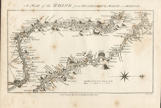
Fig 1. A Map of the Rhine from Düsseldorf
to Mainz or Mayence from John Carr's A Tour Through Holland. The river from Mainz to Andernach above;
and from Andernach to Düsseldorf below.
By the time Sir John Carr wrote his A Tour through Holland along the right and left banks of the Rhine, recording his travels in the summer and autumn of 1806, the Rhine trip was a popular route for accomplishing the famous Grand Tour. His work was typical of the time; a record of his journey copiously illustrated with 21 engraved views taken from drawings he had made and accompanied by a map of the course of the river.

Fig. 2. Panorama des Rheins und seine nächsten Umgebungen von
Mainz bis Cöln engraved by F. W. Delkeskamp and published by Friedrich Wilmans.
Place
names are in the margins, a view of Cologne (i.e. Cöln or Köln) added at the top and
one pontoon-style bridge at Köln.
This became the prototype for a long series of panoramas and a development which he and his publishing house would lead until the late 1850s. Delkeskamp's panorama covered the classic route from Mainz to Köln. The map was made up of seven sheets glued together and in order to be able to handle it better the sheets were folded as a leporello. The copper engraving on seven plates has a size of 2340 x 230 mm when unfolded.
Even if Delkeskamp is considered as the father of the leporello, he owed the idea to another: the original Rhine panorama is ascribed to Elisabeth von Adlerflycht. In 1822 a panorama on one sheet (50 x 70 cm) appeared, drawn by her, and showing Das Rheinthal von der Miindung von der Nahe bis zur Mündung der Mosel. This was a lithograph of the Rhine from Rüdesheim (below) to Coblenz (top) with Bingen centrally at the bottom. The sheet bears the signature of the artist, Elisabeth v. A. (bottom left), and that of the printer, Lithogr. V. Keller (bottom right).
Von Adlerflycht (1775-1846) was an amateur
artist from Frankfurt who made a trip along the Rhine in 1811 and sometime
later made a colourful drawing of the river landscape between Bingen and
Coblenz[6]. Her
artistic presentation, whereby the river with a 450 bend was shown
in one straight line seen from the birds-eye view together with its depiction
of relief, was completely new for that time. There are no views and text
directions take up the available space between map and border but there are
scenes of water nymphs in three corners and Father Rhine at bottom right
In 1822 Johann Friedrich Cotta, a publisher of Stuttgart, was the first person to have one of the panoramas printed. It was a work by Heinrich Keller (1778-1862), a well-known Swiss artist and cartographer. However, it was Delkeskamp's panorama which caught the imagination of successive publishers and became a popular tourist accoutrement. It was published separately and occasionally included in guide books like Tombleson's Views of the Rhine published in London by W. Tombleson & Co., and edited by W.G. Fearnside. In addition to the panorama this contained 68 plates, and a title page vignette (262 pages).

Fig 3. Das Rheinthal von der Mündung von der Nahe bis zur
Mündung der Mosel by Elisabeth von Adlerflycht. This was the inspiration for subsequent
panoramas of the Rhine. (Author´s Collection.)

Fig. 4. A later edition of Delkeskamp´s Neues Panorama des Rheins und seiner nächsten Umgebungen von Mainz bis Cöln. Note the bridge over the Mosel north of the town of Coblenz and the pontoon-style Rhine bridge.
The engravers of these panoramas became
increasingly specialised: J. W. Igler engraved the title; F. Hack, the printer,
was responsible for names and Deucker was mainly responsible for the engraving
of the panorama. Deucker was born on June 23, 1801 at Niederzündorf (now a
suburb of Cologne - Köln-Porz-Zündorf) but later moved to Frankfurt. He became
a copper engraver after studying at academies in Munich and Milan. In 1830 he
returned to Frankfurt and concentrated on steel engraving. He died in Frankfurt
on December 2, 1863[8].
Two years after the advent of the Rhine
panorama, regular steamboat passage along the river was inaugurated (from
1827). Many of the early travellers on these steamers were British, including a
multitude of artists who subsequently had their works engraved in steel (a
technique patented in London only a year earlier and which would soon become
popular). The fact that these visitors could use the Rhine route as part of
their Grand Tour to Italy was a further factor in its popularity. These
coinciding factors led to more sales of views and maps of the river. The
leporello format was then copied by a wide variety of publishers such as
Ravenstein who produced three separate maps showing the Rhine[9]. Also
Renard, whose Panorama des Rheins von Köln bis Mainz has an attractive
vignette scene of a fisherman with nets after a picture by C. Stanfield
(Sattler). This has an engraved view of the Rhine from Köln (bottom) to Mainz
with 21 engraved panels both left and right and a central engraving of Mainz at
the top; an early lithograph on three plates unfolding to 1000 x 215 mm and
with 43 separate illustrations[10].
The maps which accompanied the guide books
did not show any fixed bridges and the railway only began its progress through
the land in the 1840s. The panoramas mentioned show only three bridges - there
is one bridge at Köln, one at Mainz and another at Koblenz. All are represented
as Schiffsbrücke meaning a chain of pontoons formed from small boats
serving as a 'swing bridge'. In von Adelflycht's map only the bridge over the
Mosel on the west Rhine bank is shown as well as the primitive pontoon-style
boat-bridge at Koblenz.
Not all panoramas followed the same
format, however. A. H. Payne produced an unusual panorama in 1844 which was
engraved from original drawings in 60 views on 20 steel plates (each 300 x 200
mm). This was titled Payne's Panorama of the Rhine. Exhibiting in one
continued view, both banks of the river, from Mayence to Coblentz, the Siebengebirge
and Cologne and presented a number of strips, three to a page, each 270 x 38
mm. It was published in London by Brain and Payne. The view is the bank of the
river as seen from a boat in the middle or from the opposite bank.
![]()
![]()

Fig 5. Payne's Panorama of the Rhine.
Exhibiting in one continued view, both banks of the river, from Mayence to
Coblentz, the Slebengebirg and Cologne.
The map is accompanied by a 24-page booklet in German[11], Der
Rhein und seine Umgebungen nebst einer Karte des Rheinlaufes von Schaffause bis
zur Nordsee which literally describes the course of the Rhine from
Schafhausen near Basel to the North Sea at Katwyk op Zee. Also, a poem by M.
Claudius, Rheinweinlied, opposite page 1[12]. David
Kapp's New Panorama of the Rhine von Mentz to Cologne, although
decorated with side illustrations (as opposed to the edition noted above) does
not seem to have been so successful but is more attractive.
The next developments were the introduction of photolithography and colour as well as real photographs. About this time a number of different publishing firms appeared in this flourishing market, such as the Dresdner Kunstanstalt Aktieng, Philip Frey & Co., of Frankfurt am Main, Wilhelm Schlitz of Eisenach, A. Henry of Bonn, Michael Foppen, also of Bonn, Carl Garte of Leipzig, Hoursch and Bechstedt, Karl Rudiger Bremer of Köln or the Kunstverlag Lautz in Darmstadt (later Mertz and Lautz) as well as a number of anonymous ones. From about 1880 until the end of the century colour printing was introduced, usually one colour, as well as the glazing of paper which would protect the map and give better presentation. About 1890 the illustrations bordering the river scene are increasingly being printed in colour and by approximately 1895 the illustrations are now real photographs. The number of bridges also increased.

Fig. 6. David Kapp's New Panorama of the Rhine von Mentz to Cologne. Note the bridge at Köln which is the Dombrücke, the first fixed bridge across the Rhine, built in 1859.
Initially lithographic printers made
reproductions which might be in black and white but were sometimes in a sepia
tone or, occasionally, as in the case of Philip Frey, in a blue colour. Frey's Neuestes
Rhein Panorama von Ph.
Frey & Co in Frankfurt a. M. appeared in several versions and in varying sizes. Initially in black
and white in attractive covers it was often reprinted. One earlier printing has
an attractive sepia photolithographic view of the Rhine from Coeln [Köln] at
the top to Mainz, with 42 illustrations both left and right of buildings and
sights including the Gutenberg Monument in Mainz. There was a sixteen-page
booklet pasted in, Der Rheinstrom, with text in German followed by text
in French and English. Although the last date in the text is 1863 (referring to
Köln cathedral) the map is probably as late as 1875.
The main railway line follows the bank of the river
below Bonn (i.e., south of the town) and there are two bridges at Koblenz (the
Horchenheimer railway bridge was not built until 1879). Only one pontoon-style
bridge is visible at Mainz. The map area is approx. 120 x 1460 mm within the
border (i.e., full length but 10 mm margins left and right)[13].
The same map appeared a few years later as Neuestes Taschen Rhein-Panorama von Mainz bis Köln nach speziellen topographischen Aufnahmen ausgeführt von Ph. Frey & Co's Kunstinstitut in Frankfurt a. M. This edition folds into plain publisher's printed card boards with no title on the reverse.

Fig 7. Two examples of Frey's Neuestes Rhein Panorama. Note the new railway bridge (with train)
on the later map (below).

Again, the map has no title but is now
printed as a blue photolithographic view. There is a 24-page booklet pasted in,
Der Rheinstrom, with 1876 as the last date in the text (p. 14). However, this
edition also has a branch from the main rail line and a bridge south of Bonn
complete with a steam train crossing over the Rhine. The railway line on the
right bank of the Rhine from (opposite) Bonn to Koblenz is added.


Fig 8. Three particularly attractive covers, typical of the period 1880-1900.
Carl Garte's panorama was also produced in
the early days of colour printing. His Panorama vom Rhein - Cöln bis Mainz
has an attractive cover: gold title on ochre boards decorated with a floral
border. The map has a title on ribbons almost framing the city plan of Cologne.
This is a sepia photo-gravure map panorama within a border with 71 framed
scenes left (36) and right (35) of the river folding out to 1740 mm. No scene
panels appear at the top and bottom. The imprint centrally below the map is
Lith Kunstanstalt von Carl Garte, Leipzig.
Later editions included a 33-page descriptive
text written in three languages by Dr F Lahnek — Der Rhein von Cöln bis
Mainz[14].
The lower bridge at Mainz now looks like a normal arched bridge and the last
panel has an illustration of the Theater in Mainz replacing a view of
the bridge in the earlier state. There is an extra view — that of Hotel
Petersberg near Königswinter. The area of the map is 1730 x 150 mm, but the
complete length is 2635 mm, the extra length being taken up with nine views of
the Niederwald Nationaldenkmal (Niederwald National Monument) which was built
in 1878 to commemorate the victory over the French and two scenes of Köln and
Mainz.
A rather unusual Rhein-Panorama von Köln
bis Mainz was possibly made especially for the company Spielwarenhaus
Puppenkönig in Köln and bound in attractive red boards with a decorative
bouquet of vine leaves surrounding the central title illustration of the
Niederwald Denkmal.
On the reverse it has Spielwaren Ausstellung – von P.H. Virnich - Hoflieferant - Köln Hohestrasse 132 gegenüber der Passage - Spielwarenhaus Puppenkönig. The toy shop (Spielwarenhaus) King of Dolls (Puppenkönig) possibly commissioned the Dresdner Kunstanstalt, Aktieng., to print the map for them.

Fig 9. Carl Garte's Panorama vom Rhein - Cöln bis Mainz. Title and first panel showing the illustrations, now in colour, and Köln cathedral completed.
Again the map has no title. The panorama
landscape is in plain brown sepia tones, the river is blue but now there are
real photographic views alongside the river (27 right plus a table of widths
and depths just above bottom panel and 35 views to the left). A panel at the
top shows Köln from the Deutz bank. The length of the river panorama is 2165 mm
and it is printed in sepia[15].
There are now three bridges at Koblenz (with the Horchenheimer railway bridge
built 1879), two at Köln and a second bridge at Mainz and the railway winds
around the back of the town. This panorama has the line and projected bridge at
Bonn (passing south of town) with train and Trajekt, indicating that the
line was projected but not yet built.
The publishing company (Verlag) of Karl Rud.
Bremer was very active at the end of the century. Their publications often have
a code identifying the age of the map, e.g. 109 8 or 1/109. Map 109 8 is the Rheinlauf
von Mainz bis Köln - Gebirgszüge in Relief Manier (mountainous view with
relief presentation). The imprint is: Verlag v. Karl Rud. Bremer, Köln. This is
a printed coloured view of the river Rhine, expanded to fill the page with no
extra illustrations to the right and left. The area of the map is 1770 x 205
mm. This has the bridge at Bonn but also 'Trajekt' south of the city.
The inclusion of this 'Trajekt' bridge is surprising — it was never built! A
bridge at Bonn was finally built in 1898, but crossed over the river from the
town and not south of the city.

Fig 10. Typical depiction of the "Trajekt" bridge below Bonn circa 1880.
This map must have been produced around this time, either just after the construction or only shortly before but in the firm knowledge that it would be built. The 'ghost' bridge did not disappear immediately so plans must still have been in someone's drawer!
A later edition (1/109) Der Rhein Album
mit Panorama contains a 32-page booklet with title page and 30 photographic
views. The map has a slightly different imprint (below Mainz): Verlag v. Karl
Rud. Bremer & Co., Köln a. Rh. Above this a panel referring to Kilometerzahlen
which have been added to the map at 5km intervals along the river. There are
also extra names: Peters Aue (Mainz); Reitburg's Aue (Wiesbaden); Eltville Aue
redrawn and named; extra ferry included at Bingen, Caub St Goar etc.
Another copy of Rheinlauf von Köln bis Mainz
was produced in cheap brown paper covers and a simple art nouveau design around
the title by the H Siebenhar Verlag. The map is printed in black and white and
has been cut into two sections with the north half of the Rhine on one side,
the south section of the Rhine is on the reverse (approximate area of map 915 x
160 mm on each side). The extra names are still present but all railway lines
and bridges have been removed! Imprints below the map: D.R.G.M. and Gesetzlich
geschützt (copyright protection). Genehmigt vom Generalkommando
(approved by army command) and Verlag H Siebenhar, Köln. It would appear that
this edition, printed on cheap paper was issued during the First World War and
all important military objectives, e.g., Feste Franz (a fortress) north of
Coblenz, and all bridges, have been removed.


Fig 11. Two plans by Bremer from before and during WWI. Note absence of bridges in lower example.
Notes and Sources of Illustrations
[1] IMCoS is the International Map
Collectors Society – although there are many map groups this is currently the only
international group of map collectors. Find out more about their activities at https://www.imcos.org/.
[2] The author
would like to hear from any other Rhine panorama collectors with a view to
sharing information. All illustrations are from the author's former collection
with the exception of Fig.3, which is taken from Flüsse im Herzen Europas.
This catalogue accompanied the exhibition of the same name held at Bonn-Bad
Godesberg from 9.9.93-31.10.93, which IMCoS was privileged to attend.
[3] The
leading work on Rhine illustrations is Michael Schmitt's Die Illustrierten
Rhein-Beschreibungen 1996 Böhlau Verlag, Köln Weimar and Wien.
[4] See
Flüsse im Herzen Europas. Catalogue
number R49.
[5] Cologne is
variously written as Cöln, Coeln and signifies half of the city which became
Köln (Cologne) when it amalgamated with Deutz on the other side of the river.
[6] See Flüsse
im Herzen Europas from which this information is taken. Von
Adlerflycht's view is catalogue number R46 and is Kart. 28064 of the
Kartenabteilung der Staatsbibliothek zu Berlin.
[7] See
Flüsse im Herzen Europas, catalogue number R5(). Full title has Aufs neue nach der Natur
gezeichnet und mit den interessantesten architektonischen und geschichtlichen
Denkmälern als Randbilder geziert in Frankfurt am Main – A new drawing
according tot he landscape with interesting architectural and historical
monuments as margin illustrations produced in Frankfurt.
[8] Alfred
Sattler; Rheinpanoramen Reisehilfen und Souvenirs. A catalogue to accompany the exhibition of the same
name, held as part of the 10th Antiquariat's Fair in Cologne in September 1995.
Pages 30-33.
[9] See
Sattler E15 and Flüsse im Herzen Europas R60 and R61. Interestingly Ernest George Ravenstein moved to
Britain and produced maps, including an important one for George Philip.
[10] Sattler, Rheinpanoramen
El 1 and 8A.
[11] It is
sometimes possible to date the map from the booklet. Later booklets have more
pages, they may be dated on title page or there may be a date in the text
(although texts were used for a long period before updating).
[12] The copy
in the author's possession has a booklet with imprint: Mainz. 1867.
Verlag von D Kapp. Printer's signature on final page: Druck von J Gottsleben in
Mainz. See Sattler, Rheinpanoramen N 54.
[13] Sattler, Rheinpanoramen
H20, H21 / 9A-9D.
[14] Last date
in text of author's copy is 1880. See Sattler, Rheinpanoramen H25 and
16A.
[15] Sattler,
Rheinpanoramen 14D.
Comments
Post a Comment